![]()
![]()
The ForestTools R package offers functions to analyze remote sensing forest data. Please consult the NEWS.md file for updates.
To get started, consult the canopy analysis tutorial. For a quick guide on generating spatial statistics from ForestTools outputs, consult the spatial statistics tutorial
To cite the package use citation("ForestTools") from within R.
Plowright A. (2023). ForestTools: Tools for Analyzing Remote Sensing Forest Data. R package version 1.0.2,
https://github.com/andrew-plowright/ForestTools.Individual trees can be detected and delineated using a combination of the variable window filter (vwf) and marker-controlled watershed segmentation (mcws) algorithms, both of which are applied to a rasterized canopy height model (CHM). CHMs are typically derived from aerial LiDAR or photogrammetric point clouds.
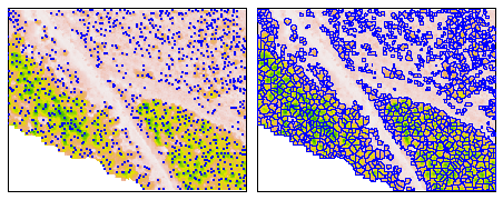
Grey-level co-occurrence matrices (GLCMs) and their associated statistics can be computed for individual trees using a single-band image and a segment raster (which can be produced using mcws). These metrics can be used as predictors for tree classification.
This library implements techniques developed in the following studies:
The following is a non-exhaustive list of studies that use the ForestTools library. Several of these papers discuss topics such as algorithm parameterization, and may be informative for users of this library.
UAV-based LiDAR and Multispectral images for forest trait retrieval by Vignali, L., Panigada, C., Tagliabue, G., Savinelli, B., Garzonio, R., Colombo, & Rossini, M. (2024)
Coupling UAV and satellite data for tree species identification to map the distribution of Caspian poplar by Miraki, M., Sohrabi, H., Fatehi, P., & Kneubuehler, M. (2024)
A novel post-fire method to estimate individual tree crown scorch height and volume using simple RPAS-derived data by Arkin, J., Coops, N. C., Daniels, L. D., & Plowright, A. (2023)
Prediction of Open Woodland Transpiration Incorporating Sun-Induced Chlorophyll Fluorescence and Vegetation Structure by Gao, S., Woodgate, W., Ma, X., & Doody, T. M. (2023)
From Local to Micro: Exploratory Data Analysis on Urban Forests and Microclimates in Portland, Oregon, USA by Yao, X., & Kim, M. (2023)
Mapping and monitoring of vegetation regeneration and fuel under major transmission power lines through image and photogrammetric analysis of drone-derived data by Sos, J., Penglase, K., Lewis, T., Srivastava, P. K., Singh, H., & Srivastava, S. K. (2023)
Patterns of Florida Bonneted Bat Occupancy at the Northern Extent of Its Range by Schorr, R. A., Pitcher, K. A., Aldredge, R. A., & Lukacs, P. M. (2023)
Remotely sensed and ground measurements reveal intraspecific differences in early season needle unfolding and senescence, but lack of variability in litter flammability of Pinus halepensis by Lombardi, E., Kefauver, S.C., Serrano, L., Sin, E., Piñas-Bonilla, P., Pérez, B., Luna, B., Zavala, G., de Dios, V.R. and Voltas, J. (2023)
A New Approach to Estimate Fuel Budget and Wildfire Hazard Assessment in Commercial Plantations Using Drone-Based Photogrammetry and Image Analysis by Penglase, K., Lewis, T., & Srivastava, S. K. (2023)
Biomass Estimation of Urban Forests Using LiDAR and High-Resolution Aerial Imagery in Athens–Clarke County, GA by Henn, K. A., & Peduzzi, A. (2023)
Monitoring Individual Tree Phenology in a Multi-Species Forest Using High Resolution UAV Images by Kleinsmann, J., Verbesselt, J., & Kooistra, L. (2023)
Urban Treetop Detection and Tree-Height Estimation from Unmanned-Aerial-Vehicle Images by Wu, H., Zhuang, M., Chen, Y., Meng, C., Wu, C., Ouyang, L., Liu, Y., Shu, Y., Tao, Y., Qiu, T. and Li, J. (2023)
Modeling Biometrie Attributes from Tree Height Using Unmanned Aerial Vehicles (UAV) in Natural Forest Stands by Quiñonez-Barrazal, G., Pompa-García, M., Vivar-Vivar, E.D., Gallardo-Salazar, J.L., Hernández, F.J., Rodríguez-Flores, F.D.J., Solís-Moreno, R., Bretado-Velázquez, J.L., Valdez-Cepeda, R.D. and Hernández-Díaz, J.C. (2023)
Detection of standing retention trees in boreal forests with airborne laser scanning point clouds and multispectral imagery by Hardenbol, A. A., Korhonen, L., Kukkonen, M., & Maltamo, M. (2023)
Multi-temporal NDVI analysis using UAV images of tree crowns in a northern Mexican pine-oak forest by Gallardo-Salazar, J. L., Rosas-Chavoya, M., Pompa-García, M., López-Serrano, P. M., García-Montiel, E., Meléndez-Soto, A., & Jiménez-Jiménez, S. I. (2023)
A Lidar-based Method for 3D Urban Forest Evaluation and Microclimate Assessment, a Case Study in Portland, Oregon, USA by Yao, X., & Kim, M. (2023)
Effects of long‐term fixed fire regimes on African savanna vegetation biomass, vertical structure and tree stem density by Singh, J., Boucher, P. B., Hockridge, E. G., & Davies, A. B. (2023)
The role of in-channel vegetation in driving and controlling the geomorphic changes along a gravel-bed river by Picco, L., Pellegrini, G., Iroumé, A., Lenzi, M. A., & Rainato, R. (2023)
Using photogrammetry to assess the recovery of a cypress forest and its impact on water-borne erosion. Case study: Guadalupe Island by Vera-Ortega, L. A., Hinojosa-Corona, A., Luna, L., & Gudiño-Elizondo, N. (2023)
UAV data collection parameters impact on accuracy of Scots pine stand mensuration by Zadorozhniuk, R. (2023)
Risk Analysis for Asset Protection in Hoyt Arboretum, Portland, OR by Kossnar, N. (2023).
Modelling internal tree attributes for breeding applications in Douglas-fir progeny trials using RPAS-ALS by du Toit, F., Coops, N. C., Ratcliffe, B., El-Kassaby, Y. A., & Lucieer, A. (2023)
Mountain Tree Species Mapping Using Sentinel-2, PlanetScope, and Airborne HySpex Hyperspectral Imagery by Kluczek, M., Zagajewski, B., & Zwijacz-Kozica, T. (2023)
Use of Drone RGB Imagery to Quantify Indicator Variables of Tropical-Forest-Ecosystem Degradation and Restoration by Lee, K., Elliott, S., & Tiansawat, P. (2023)
Individual Tree Identification in ULS Point Clouds Using a Crown Width Mixed-Effects Model Based on NFI Data by Kubišta, J., & Surový, P. (2022)
Utilizing Single Photon Laser Scanning Data for Estimating Individual Tree Attributes by Simula, J., Holopainen, M., & Imangholiloo, M. (2022)
UAV-LiDAR and RGB Imagery Reveal Large Intraspecific Variation in Tree-Level Morphometric Traits across Different Pine Species Evaluated in Common Gardens by Lombardi, E., Rodríguez-Puerta, F., Santini, F., Chambel, M. R., Climent, J., Resco de Dios, V., & Voltas, J. (2022)
Cross-Comparison of Individual Tree Detection Methods Using Low and High Pulse Density Airborne Laser Scanning Data by Sparks, A. M., Corrao, M. V., & Smith, A. M. (2022)
Slow development of woodland vegetation and bird communities during 33 years of passive rewilding in open farmland by Broughton, R. K., Bullock, J. M., George, C., Gerard, F., Maziarz, M., Payne, W. E., Scholefield, P. A., Wade, D., & Pywell, R. F. (2022)
Application of unmanned aerial system structure from motion point cloud detected tree heights and stem diameters to model missing stem diameters by Swayze, N. C., & Tinkham, W. T. (2022)
Limited increases in savanna carbon stocks over decades of fire suppression by Zhou, Y., Singh, J., Butnor, J. R., Coetsee, C., Boucher, P. B., Case, M. F., Hockridge, E. G., Davies, A. B., & Staver, A. C. (2022)
Automated Inventory of Broadleaf Tree Plantations with UAS Imagery by Chandrasekaran, A., Shao, G., Fei, S., Miller, Z., & Hupy, J. (2022)
Use of Unoccupied Aerial Systems to Characterize Woody Vegetation across Silvopastoral Systems in Ecuador by Iñamagua-Uyaguari, J. P., Green, D. R., Fitton, N., Sangoluisa, P., Torres, J., & Smith, P. (2022)
Democratizing macroecology: Integrating unoccupied aerial systems with the National Ecological Observatory Network by Koontz, M. J., Scholl, V. M., Spiers, A. I., Cattau, M. E., Adler, J., McGlinchy, J., Goulden, T., Melbourne, B. A., & Balch, J. K. (2022).
An Integrated Method for Estimating Forest-Canopy Closure Based on UAV LiDAR Data by Gao, T., Gao, Z., Sun, B., Qin, P., Li, Y., & Yan, Z. (2022)
Detection of standing retention trees in boreal forests with airborne laser scanning point clouds and multispectral imagery by Hardenbol, A. A., Korhonen, L., Kukkonen, M., & Maltamo, M. (2022)
Optimizing aerial imagery collection and processing parameters for drone-based individual tree mapping in structurally complex conifer forests by Young, D. J., Koontz, M. J., & Weeks, J. (2022)
Assessing Structural Complexity of Individual Scots Pine Trees by Comparing Terrestrial Laser Scanning and Photogrammetric Point Clouds by Tienaho, N., Yrttimaa, T., Kankare, V., Vastaranta, M., Luoma, V., Honkavaara, E., … & Saarinen, N. (2022)
SiDroForest: a comprehensive forest inventory of Siberian boreal forest investigations including drone-based point clouds, individually labeled trees, synthetically generated tree crowns, and Sentinel-2 labeled image patches by van Geffen, F., Heim, B., Brieger, F., Geng, R., Shevtsova, I. A., Schulte, L., … & Kruse, S. (2022)
Individual urban trees detection based on point clouds derived from UAV-RGB imagery and local maxima algorithm, a case study of Fateh Garden, Iran by Azizi, Z., & Miraki, M. (2022)
Effect of varied unmanned aerial vehicle laser scanning pulse density on accurately quantifying forest structure by Sumnall, M. J., Albaugh, T. J., Carter, D. R., Cook, R. L., Hession, W. C., Campoe, O. C., … & Thomas, V. A. (2022)
Correcting the Results of CHM-Based Individual Tree Detection Algorithms to Improve Their Accuracy and Reliability by Lisiewicz, M., Kamińska, A., Kraszewski, B., & Stereńczak, K. (2022)
Combining aerial photos and LiDAR data to detect canopy cover change in urban forests by Coupland, K., Hamilton, D., & Griess, V. C. (2022)
Effects of Flight and Smoothing Parameters on the Detection of Taxus and Olive Trees with UAV-Borne Imagery by Ottoy, S., Tziolas, N., Van Meerbeek, K., Aravidis, I., Tilkin, S., Sismanis, M., Stavrakoudis, D., Gitas, I. Z., Zalidis, G. & De Vocht, A. (2022)
Modeling the Missing DBHs: Influence of Model Form on UAV DBH Characterization by Tinkham, W. T., Swayze, N. C., Hoffman, C. M., Lad, L. E., & Battaglia, M. A. (2022)
Mapping Tree Canopy in Urban Environments Using Point Clouds from Airborne Laser Scanning and Street Level Imagery by Rodríguez-Puerta, F., Barrera, C., García, B., Pérez-Rodríguez, F., & García-Pedrero, A. M. (2022)
Extraction of individual trees based on Canopy Height Model to monitor the state of the forest by Douss, R., & Farah, I. R. (2022)
Aprisco Field Station: the spatial structure of a new experimental site focused on agroecology by O’Brien, M. J., Carbonell, E. P., & Schöb, C. (2022)
UAV-Based Characterization of Tree-Attributes and Multispectral Indices in an Uneven-Aged Mixed Conifer-Broadleaf Forest by Vivar-Vivar, E. D., Pompa-García, M., Martínez-Rivas, J. A., & Mora-Tembre, L. A. (2022)
Detectability of the Critically Endangered Araucaria angustifolia Tree Using Worldview-2 Images, Google Earth Engine and UAV-LiDAR by Saad, F., Biswas, S., Huang, Q., Corte, A. P. D., Coraiola, M., Macey, S., Marcos Bergmann, M., & Leimgruber, P. (2021)
Fine scale mapping of fractional tree canopy cover to support river basin management by Gao, S., Castellazzi, P., Vervoort, R. W., & Doody, T. M. (2021)
Above Ground Biomass Estimation of Syzygium aromaticum using structure from motion (SfM) derived from Unmanned Aerial Vehicle in Paninggahan Agroforest Area, West Sumatra by Harapan, T. S., Husna, A., Febriamansyah, T. A., Mutashim, M., Saputra, A., Taufiq, A., & Mukhtar, E. (2021)
Influence of flight parameters on UAS-based monitoring of tree height, diameter, and density by Swayze, N. C., Tinkham, W. T., Vogeler, J. C., & Hudak, A. T. (2021)
Detection of aspen in conifer-dominated boreal forests with seasonal multispectral drone image point clouds by Hardenbol, A. A., Kuzmin, A., Korhonen, L., Korpelainen, P., Kumpula, T., Maltamo, M., & Kouki, J. (2021)
Correcting tree count bias for objects segmented from lidar point clouds by Strub, M. R., & Osborne, N. (2021)
Arboricoltura di precisione: un nuovo approccio alla gestione del rischio caduta alberi basato sulla Geomatica by De Petris, S., Sarvia, F., & Borgogno-Mondino, E. (2021)
Canopy Extraction and Height Estimation of Trees in a Shelter Forest Based on Fusion of an Airborne Multispectral Image and Photogrammetric Point Cloud by Wang, X., Zhao, Q., Han, F., Zhang, J., & Jiang, P. (2021)
Uav-based lidar scanning for individual tree detection and height measurement in young forest permanent trials by Rodríguez-Puerta, F., Gómez-García, E., Martín-García, S., Pérez-Rodríguez, F., & Prada, E. (2021)
UAV-derived forest degradation assessments for planning and monitoring forest ecosystem restoration: towards a forest degradation index by Lee, K. (2021)
Potential for Individual Tree Monitoring in Ponderosa Pine-Dominated Forests Using Unmanned Aerial System Structure from Motion Point Clouds by Creasy, M. B., Tinkham, W. T., Hoffman, C. M., & Vogeler, J. C. (2021)
Assessment of Above-Ground Carbon Storage by Urban Trees Using LiDAR Data: The Case of a University Campus by Gülçin, D., & van den Bosch, C. C. K. (2021)
Influence of Agisoft Metashape Parameters on UAS Structure from Motion Individual Tree Detection from Canopy Height Models by Tinkham, W. T., & Swayze, N. C. (2021)
Ground-Penetrating Radar as phenotyping tool for characterizing intraspecific variability in root traits of a widespread conifer by Lombardi, E., Ferrio, J. P., Rodríguez-Robles, U., de Dios, V. R., & Voltas, J. (2021)
Bridging the genotype–phenotype gap for a Mediterranean pine by semi‐automatic crown identification and multispectral imagery by Santini, F., Kefauver, S. C., Araus, J. L., Resco de Dios, V., Martín García, S., Grivet, D., & Voltas, J. (2021)
Tracking the rates and mechanisms of canopy damage and recovery following Hurricane Maria using multitemporal lidar data by Leitold, V., Morton, D. C., Martinuzzi, S., Paynter, I., Uriarte, M., Keller, M., Keller, M., Ferraz, A., Cook, B. D., Corp, L. A., & González, G. (2021)
Cross-scale interaction of host tree size and climatic water deficit governs bark beetle-induced tree mortality by Koontz, M. J., Latimer, A. M., Mortenson, L. A., Fettig, C. J., & North, M. P. (2021)
The wildlife‐livestock interface on extensive free‐ranging pig farms in central Spain during the “montanera” period by Triguero‐Ocaña, R., Laguna, E., Jiménez‐Ruiz, S., Fernández‐López, J., García‐Bocanegra, I., Barasona, J. Á., … & Acevedo, P. (2020)
Supporting Assessment of Forest Burned Areas by Aerial Photogrammetry: The Susa Valley (NW Italy) Fires of Autumn 2017 by De Petris, S., Momo, E. J., & Borgogno-Mondino, E. (2020)
Applying unmanned aerial vehicles (UAVs) to map shrubland structural attributes in northern Patagonia, Argentina by Gonzalez Musso, R. F., Oddi, F. J., Goldenberg, M. G., & Garibaldi, L. A. (2020)
Automated Canopy Delineation and Size Metrics Extraction for Strawberry Dry Weight Modeling Using Raster Analysis of High-Resolution Imagery by Abd-Elrahman, A., Guan, Z., Dalid, C., Whitaker, V., Britt, K., Wilkinson, B., & Gonzalez, A. (2020)
Northern Bobwhite Non‐Breeding Habitat Selection in a Longleaf Pine Woodland by Kroeger, A. J., DePerno, C. S., Harper, C. A., Rosche, S. B., & Moorman, C. E. (2020)
Evaluation of Features Derived from High-Resolution Multispectral Imagery and LiDAR Data for Object-Based Support Vector Machine Classification of Tree Species by Roffey, M., & Wang, J. (2020)
Mapping Species at an Individual-Tree Scale in a Temperate Forest, Using Sentinel-2 Images, Airborne Laser Scanning Data, and Random Forest Classification by Plakman, V., Janssen, T., Brouwer, N., & Veraverbeke, S. (2020)
High-resolution multisensor remote sensing to support date palm farm management by Mulley, M., Kooistra, L., & Bierens, L. (2019)
Quantifying canopy tree loss and gap recovery in tropical forests under low-intensity logging using VHR satellite imagery and airborne LiDAR by Dalagnol, R., Phillips, O. L., Gloor, E., Galvão, L. S., Wagner, F. H., Locks, C. J., & Aragão, L. E. (2019)
Forest inventory sensitivity to UAS-based image processing algorithms by Maturbongs, B., Wing, M. G., Strimbu, B., & Burnett, J. (2019)
Remote sensing pipeline for tree segmentation and classification in a mixed softwood and hardwood system by McMahon, C. A. (2019)
Tree height in tropical forest as measured by different ground, proximal, and remote sensing instruments, and impacts on above ground biomass estimates by Laurin, G. V., Ding, J., Disney, M., Bartholomeus, H., Herold, M., Papale, D., & Valentini, R. (2019)
Advances in the Derivation of Northeast Siberian Forest Metrics Using High-Resolution UAV-Based Photogrammetric Point Clouds by Brieger, F., Herzschuh, U., Pestryakova, L. A., Bookhagen, B., Zakharov, E. S., & Kruse, S. (2019)
Multi-scale Assessment of Northern Bobwhite and White-tailed Deer Habitat Selection in Longleaf Pine Woodlands by Kroeger, A. J. (2019)